Western Australia State Map 10e

Author: Hema Maps Australia Staff

Stock information

General Fields

  • : 12.99 NZD
  • : 9781865008752
  • : Hema Maps Pty, Limited
  • : Hema Maps
  • :
  • : 0.09
  • : February 2015
  • : 250mm X 140mm
  • : Australia
  • : 12.99
  • :
  • :
  • :
  • : books

Special Fields

  • :
  • :
  • : Hema Maps Australia Staff
  • : State Map Ser.
  • : Sheet map, folded
  • : 10th Revised edition
  • :
  • :
  • :
  • :
  • :
  • :
  • :
  • :
  • :
  • :
  • :
  • :
  • :
  • :
Barcode 9781865008752
9781865008752

Description

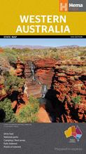
A map of Western Australia for touring throughout the state that has camping and rest areas, 24-hour fuel and points of interest marked on the mapping. On the reverse are CBD and through road maps of Perth in addition to inset maps of Leeuwin-Naturaliste National Park, Cape Range National Park, Nambung National Park, Francois Peron National Park, Purnululu National Park, Walpole-Nornalup National Park and Karijini National Park. Also included are listed national parks and information centres within Western Australia.